World Machine: Terrains from NASA Satellite images

  • Overview
  • Curriculum
  • Instructor
  • Review

About This Course

World Machine: Find NASA Satellite images, import them, create terrains, go wild with your creativity using ANY image

You will learn how to:

- import real terrains from NASA Satellite Images to World Machine
- know where to find satellite images the easy way for quick results
- and where to find high resolution satellite images for high level of detail work

You will also learn how to

- create any terrain from clipart images

- create terrains from ANY images whatsoever even color pictures


  • To make your own realistic terrains from real satellite images of the NASA

  • To create terrains from clipart

  • To create terrains from ANY image whatsoever, even color pictures

Course Curriculum

Instructor

Profile photo of VFX 3D Pro
VFX 3D Pro

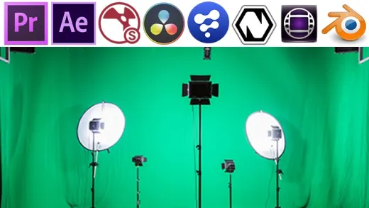
3D Artist specialised in 3D Environments & Visual Effects, I work in film environment so I'm into incorporating 3D element in live action and Compositing using Fusion, Nuke, Natron and Adobe After Effects.3D software used: E-on Vue, World Machine, Terragen, ZBrush, Maya, 3ds Max, Houdini, Blender, Cinema4D, Nuke, Adobe Creative Cloud, Mari, Marvelous Designer, and More.

Review
4.9 course rating
4K ratings
ui-avatar of jeremy burt
Jeremy B.
5.0
11 months ago

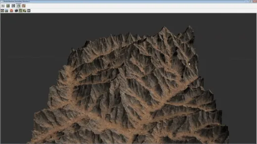
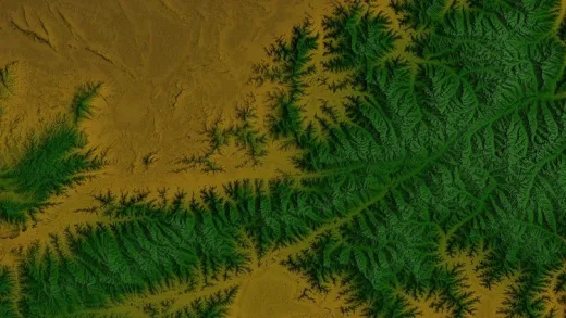
Craft realistic landscapes with World Machine: Terrains from NASA Satellite Images! Transform raw data into stunning terrains. Thank you for exploring with us!

  • Helpful
  • Not helpful
ui-avatar of Mike Crane
Mike C.
3.0
3 years ago

Informative course however it is a bit dated...it needs to be updated to remove the Terrain Party section since that tool no longer builds height data maps. At least a note should be added to the course information to inform others about the outdated information before purchasing.

  • Helpful
  • Not helpful
ui-avatar of Catherine Scott
Catherine S.
2.5
4 years ago

no

  • Helpful
  • Not helpful
ui-avatar of Evgeny Kalachikhin
Evgeny K.
3.0
4 years ago

Nice course, but the information is partially outdated. Most of the things could be explained much shorter, that saves time. Thank you anyway.

  • Helpful
  • Not helpful
ui-avatar of Jeremy Harvey
Jeremy H.
5.0
6 years ago

Amazing

  • Helpful
  • Not helpful
ui-avatar of Leonard Halmrast
Leonard H.
4.5
6 years ago

I'm now ready to take on World Machine! Learned a lot on using this program and how to use real world terrains.

  • Helpful
  • Not helpful
ui-avatar of Ching Wei Yang
Ching W. Y.
4.0
6 years ago

Overall a good course that imparts how to use real-world height map data and images to create terrains in world machine.

Narration could be a bit slower and less repetitive, but the sound quality was good and volume came across clear for me.

2 Negatives:

1) the instructor never touches on how to export your newly created terrain for use in other applications (e.g. game engines).

2) given the immense presence and popularity of Google Earth, that resource should have been touched on along with the others he does mention (and one resource is of notable value, so yeah, buy the course.)

  • Helpful
  • Not helpful
ui-avatar of Mohamed Hussein Yousif Ahmed
Mohamed H. Y. A.
5.0
6 years ago

A nice and informative course that deals with terrains and Nasa satellite images. I liked it a lot.

  • Helpful
  • Not helpful
ui-avatar of Roozbeh Manouchehri
Roozbeh M.
5.0
7 years ago

I love the pace of the course. He really explains everything as much as needed. He is very experienced and know exactly what to do. I have learned exactly what I expected from the title of the course and now I can make amazing terrain from real-world data. One of the best courses on World Machine.

  • Helpful
  • Not helpful
Leave A Reply

Your email address will not be published. Required fields are marked *

Ratings

Courses You May Like

Lorem ipsum dolor sit amet elit
Show More Courses